
Become an Urban Planner for Wildlife!
PURPOSE
This activity takes many ecological concepts and shows how they can be applied in a real-life scenario. In this simulation, students take on the role of town planners as they try to preserve wildlife corridors for animals in the face of rapid urban growth.
GRADE LEVELS
7-9
TIME NEEDED
60 minutes
Curriculum LINKS
Science 7, Unit A, Outcomes 1,3,4
Science 9, Unit A, Outcomes 4
MATERIALS NEEDED
Download: Four overhead maps (pdf)
Instructions
1: Tell the students that wildlife biologists are learning that many animals – particularly large mammals – need more space than anyone had previously thought, and that many protected areas are simply too small to sustain permanent populations of these animals. Define the following terms for the students:
Biologists and some town planners use these concepts as criteria as they seek to minimize the effects of humans and human development on various animal species and the ecosystem in which they live.
The following questions accompany the four maps (overheads) and are designed to promote discussion and to lead students through the simulation activity.
Overhead #1: 100 years ago
This overhead shows the natural situation 100 years ago before any human development. Tell the students that the mountains in this area are very steep, are mainly rock and ice, contain no food, and cannot be used by grizzly bears. Their only habitat is in the valley bottoms where they can find the berries, roots, and other vegetation that comprises the majority of their diet.
2: Ask the students: Where is the grizzly bear habitat?
Students should correctly identify the valley bottom (areas A, B, and C) as bear habitat. Although bears have very large territories, they overlap with each other. Tell the students that many bears use this area.
Where are the core refugia and wildlife corridors on this map?
All of areas A, B, and C are called core refugia; all those valleys that join the refugia are wildlife corridors. Illustrate how a grizzly bear might wander from Refugia A to B using a wildlife corridor.
Overhead #2: The Present
This overhead shows what has changed now that humans have entered the valley.
3: Ask the students: What has changed in this valley?
Students should note changes to the valley: the road, the town, and the creation of a National Park that now protects Refugia A.
How would these changes affect the grizzly bear?
Although grizzly bears would not be aware of the park boundary, there are definitely some things they would notice:
- The road. A major cause of grizzly bear deaths in the mountains is from vehicles traveling on highways and roads.
- Less habitat. The creation of the town and the road has used up bear habitat.
- The town. Under normal conditions grizzlies will not come close to humans or human settlement; hunting and other persecution by humans has taught them to avoid us and our development.
- More people. Bears may become habituated when humans live in grizzly bear habitat. People often don’t manage their garbage to make sure bears don’t get into it. In such cases, bears end up either getting killed or being moved to another area where they have to compete with other bears or other people to survive. The majority of bears who die are habituated.
Can bears still access Refugia B?
We don’t really know. Biologists are not sure what the ideal width of a corridor is. If it is too narrow, shy animals like grizzlies may stop using it.
If you were a biologist, how would you find out if bears were using Refugia B?
Scientists could use a variety of techniques. They could radio-collar the animals in the area to monitor where the animals travel; they could look for bear signs, or use cameras in the wildlife corridor in the hopes of photographing a bear actually using the area. (For a dose of reality, ask students to calculate a budget for this research! Where might all this money come from?)
4: Define the term islandization for your students. If the town were to completely cut off Refugia B from A and C, we would say that this part of the habitat has been “islandized.” This phenomenon is also known as habitat fragmentation.
Recent research in Banff National Park and Kananaskis Country indicates that the grizzly bear population may be in danger, partly because of these factors.
Overhead #3: A Possible Future
5: Have the students examine the map, and ask them: What further changes have occurred in the valley?
Students should notice that things have changed – and not for the better as far as grizzlies are concerned! The town has completely blocked off Refugia B, and is also threatening to block the wildlife corridor connecting Refugia A and C. The twinned highway takes up more habitat and makes highway crossings more hazardous for bears and all other animals.
Tell students that under the conditions outlined here bears are likely to become extirpated (locally extinct) in this area. Point out that this picture represents only one of a number of possible futures for the valley. A Preferred Future is one where human action that occurs today creates a more desirable future (i.e. grizzlies are not extirpated).
6: Tell the students to imagine that they are today’s town politicians and planners, and are responsible for planning what the valley will look like in their Preferred Future.
Ask them: Is it practical to just say that the town cannot grow any more?
This is possible – but Canadian towns or cities rarely decide to not grow (Okotoks, AB is one of the rare exceptions). Not only are all municipal bylaws written to encourage growth, but capping the growth of towns like Canmore or Banff have proven to be very unpopular with residents who fear the law of supply and demand will increase the value of their property – and the property taxes that they will have to pay. Even the town site of Banff, which lies within a national park, continues to increase its commercial growth at a rapid rate.
Our tendency to opt for continued growth in a finite area is similar to a much larger concern: the increasing human population on the planet.
Other questions for discussion:
- Will our quality of life remain the same in this future?
- Is it possible for the town to restore land that is developed (a golf course, for example) back to its natural state? Why or why not?
- If you said ‘no”, do you think that this will always be the case, or might public attitudes change in the future?
Ask the students to assume that some growth is necessary.
Using Overhead #2, have students show how they would make the town grow to allow the population to triple – but without ruining the valley for the wildlife. This is their “Preferred Future.”
What about the highway: could you decrease its size, or even close it?
Remind students that highway mortality is the #1 cause of death for Banff’s Bow Valley wolf pack, and the #2 cause of death for grizzly bears. Some might say that highways are essential for humans: we need them for their own travel, the flow of goods from the prairies to the Pacific Ocean, and that they are here to stay. Ask students if they agree with this statement.
What changes can be made to mitigate the effects of the highway on the ecosystem? What recommendations would you make to future park managers in order to help manage the impact of additional people who all want to access the remaining wild areas for recreation?
Overhead #4: A Preferred Future
7: Have students present their preferred futures to the class. The overhead provided is just one example of a Preferred Future and shows how the impact of additional humans, although considerable, can be reduced by responsible planning. Ask the students:
What new features are shown on this map?
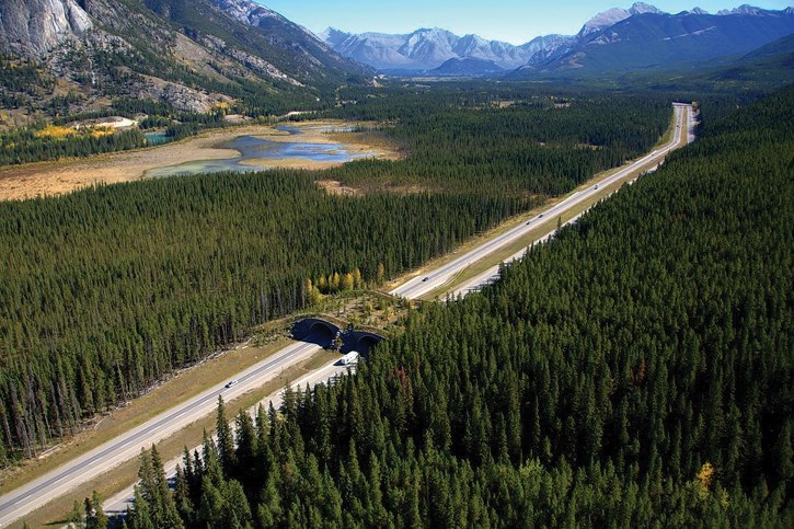
Although the population has tripled, the town has grown to less than three times its previous size because buildings are now higher and population density in town is greater. It has expanded parallel to the valley wall, allowing a corridor to stay open. Through a land swap negotiated by the town, part of a developed golf course area has been restored to its natural state in order to improve access to Refugia B, while the developer has been allowed to build elsewhere in town. The southern part of town is connected to the main town by a narrow road that is posted with low speed limits, speed bumps, and educational signage to reduce wildlife mortality. Although the highway has been twinned in response to increased use, it has been fenced in, forcing animals to use the new overpasses that have been built to allow animals to cross above the highway in safety.
Discussion
Tell students that this simulation is based on real life: the area shown in the overheads is based on recent development in the Bow Valley in the area of Banff National Park (area A), Wind Valley (area C) and the rapidly growing town of Canmore. Some of the measures described in the Preferred Future section have been carried out (i.e. the highway in Banff National Park has been fenced and new animal overpasses constructed)
More Bring Nature Home for Teachers
Bring Nature Home is our online database of tried-and-tested CPAWS Southern Alberta activities! Here are some ways that you can bring nature home (or to the classroom) today!
Habitat and Climate Change
Discover how climate is changing habitat for different animals such as the grizzly bear.…
Habitat Stretch and Shrink
Bring nature home with this fun environmental education activity! In Habitat Stretch and Shrink experience habitat loss and its ecosystem…
Observational Mapping
Discover the abiotic and biotic components of your local ecosystem.…